


Gordon Update
September 3rd, 2018
“Holy hurricane, Batman.”
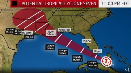
[Update: 8:27 a.m.] There is something brewing in the Florida Straits and it could become a tropical storm and a hurricane. Currently the disturbance is known as “Potential Tropical Cyclone Seven.”
It could become “Gordon.”
As of the 5 a.m. advisory this morning, New Orleans is dead-center in the dreaded “Cone of Uncertainty.” Tropical storm watches have been issued for the Louisiana, Mississippi and Alabama coasts.
If this does not form into something stronger, NOAA’s hurricane center predicts winds for New Orleans to reach 60 mph.
Bucs fans are on edge because of this. Why? First, the Bucs open the season in New Orleans in six days. Additionally, Bucs fans still vividly remember last year the Bucs had their season opener pushed back due to Hurricane Irma. That very likely screwed up the entire season.
Don’t fret, Bucs fans, this isn’t nearly expected to be anywhere close to Irma’s strength. Plus, by the time Sunday rolls around, this unpredictable storm is expected to be in Oklahoma if not beyond.
Could Bucs fans get wet attending the Bourbon Street Takeover on Saturday? Maybe. All the more reason to sit in a bar on Bourbon Street.
[Update: 8:27 a.m.] The storm is officially now known as “Gordon” and is a tropical storm.


September 3rd, 2018 at 6:23 am
Take a good look at that model. Let me ask a question: have you EVER seen a tropical storm/hurricane travel in a straight line like that?
Nope.
The always turn north once the reach the Gulf. That storm will hit the panhandle or northern florida.
September 3rd, 2018 at 6:24 am
I’m looking at the latest Eurotrash model from an hour ago and it has this as a disorganized system, maybe tropical depression, heading into New Orleans with about 30 mph winds (and that’s over open water, wind speeds on land is much lower). There’s nothing I see anywhere that says it will have anything close to 60mph winds. The Eurotrash model is the most aggressive, the American model has a completely disorganized low pressure system with less than 30mph winds. In other words, it’s nothing. If you didn’t know this was coming you’d wake up and say, hum, it’s a bit breezy this morning.
Something of more interest however is the long range Eurotrash model has about a cat 3 hurricane ready to plow directly into North Carolina by late next week. Now, long range forecasts like that are rarely accurate, as in I’m not sure it’s ever been accurate like 10 days out. The interesting part is not where it’s making landfall, it’s that the models are predicting the hurricane, which it has showed for days, won’t turn out to sea. That’s one to watch, even for us here in FL since if something does form to block that northern recurve to sea the entire east coast has to pay attention. Again, very long forecast period and it’s hardly ever right, but something to keep an eye on this week – and I’m sure you’ll hear about it soon from the media.
September 3rd, 2018 at 6:24 am
‘the’ = ‘they’
Stupid tablet…
September 3rd, 2018 at 6:27 am
They always weaken over land. The only way the storm reaches Cat3 is if it loops in the Gulf, or rebuilds strenth once in the North Atlantic again.
September 3rd, 2018 at 6:30 am
I’ve been through…5-7?…hurricanes. They no longer concern me and 98% of the time completely miss Tampa, St Pete, Bradenton and Sarasota areas.
Last year was a 2% year.
September 3rd, 2018 at 6:41 am
Sorry, the second storm I mentioned is a storm still forming way out in the Atlantic – had nothing to do with the possible tropical depression that could hit NO. Also looking at the Miami radar the current NO storm will pass over south Florida in the next few hours – has OK circulation for this early and going over the Everglades won’t really hurt it. If this storm had started a day or two earlier, or went south of FL and moved slower, then it could have a chance to be a min hurricane, but I don’t see how that is possible right now, and the models say at most it’s the weakest tropical storm you can name – and since we are 2 days out, well those forecast are generally very good good.
September 3rd, 2018 at 6:48 am
B. Bonzai go to your tablet’s Settings menu and turn off the Auto Correct option. Pretty simple.
September 3rd, 2018 at 6:51 am
@Joe … “If this does form into something stronger, currently NOAA’s hurricane center predicts winds for New Orleans to reach 50 mph.” Looks like y’all are trying to stir the pot with this one Joe. Hurricane Center is predicting 50 MPH winds? We get those all the time with our afternoon thunderstorms here. And by Sunday, it’s “expected to be in Oklahoma if not beyond”? Our game with New Orleans is still scheduled for Sunday in the Dome, isn’t it? Hurricane Irma “very likely screwed up the entire season” kinda seems like an overstatement. Irma didn’t help I’m sure, but I kinda think that having a mediocre team had a much more significant effect on our 5-11 season.
But my favorite is still, “Bucs fans are on edge because of this.” I might’ve been ‘on edge’ as Hurricane Irma passed directly over my house last September … with me in the house. When a 50 MPH ‘maybe’ tropical storm ‘maybe’ hits New Orleans days before our Game 1 with the Saints, nah I’m not on edge.
September 3rd, 2018 at 7:20 am
@Defense Rules
After checking with hurricane central aka spaghettimodels dot com, I am pretty confident that rain from this “storm hassle” will be gone by Thursday night!!!!!!!!!
September 3rd, 2018 at 7:39 am
Boy, the media is really pushing this glorified gust of wind up the boob tube. Guess they are desperate to prove that their predictions regarding the dramatic effects of global happenings is accurate.
September 3rd, 2018 at 8:25 am
Marc:
You wouldn’t believe how many queries Joe got about this storm yesterday and last night. Like you, don’t think this will be anything more than a thunderstorm but it does have people’s attention.
September 3rd, 2018 at 8:36 am
Buccaneer Bonzai Says:
September 3rd, 2018 at 6:23 am
Take a good look at that model. Let me ask a question: have you EVER seen a tropical storm/hurricane travel in a straight line like that?
Nope.
The always turn north once the reach the Gulf. That storm will hit the panhandle or northern florida.
—————————
Hurricanes zig and zag due to physics and steering which is why the margin of error can be up to 200 miles. The motion with this one is pretty straightforward (Louisiana to Alabama most likely) because of the dominant high just off Florida.
And it won’t develop past a tropical storm due to fast movement and sheer. Not enough time to develop at this rate. The storm won’t be an issue for the weekend and the game will be played.
September 3rd, 2018 at 8:47 am
The only Buc fan who is worried about Gordon is you Joe! LoL.
September 3rd, 2018 at 9:05 am
If it’s suppose to be in Oklahoma come Sunday, then who the hell cares Joe? Try to find some info on players we might be looking into or could be nice fits.
September 3rd, 2018 at 9:15 am
It is kinda ironic that the location of the Bucs week 1 opponents the past two years has been the target of a tropical system.
September 3rd, 2018 at 9:27 am
Looking at the radar of the storm now…it’s slightly further north than the spaghetti models are showing…which means it is starting to turn already…just a little, but enough to probably make it miss NO.
September 3rd, 2018 at 9:27 am
Well they could move this game to Tampa an playbour next game in BO
September 3rd, 2018 at 9:29 am
SOEbuc Says
“If it’s suppose to be in Oklahoma come Sunday, then who the hell cares Joe?”
You know, the Joes provide us with all sorts of team-related news. The guys work hard.
If they want to tell us about the storm, I have no issue with it. And I believe hardly anyone else does either.
So get off your high horse, girl.
September 3rd, 2018 at 9:31 am
@feelthepewterpower
I agree, but once they hit land they weaken, and once they reach the outer perimeter of the Gulf, they usually turn to the right.
September 3rd, 2018 at 9:39 am
Buccaneer Bonzai Says:
September 3rd, 2018 at 9:31 am
@feelthepewterpower
I agree, but once they hit land they weaken, and once they reach the outer perimeter of the Gulf, they usually turn to the right.
—————————-
Not always…the time of the year matters too….early september is too early for storms to turn right as their aren’t usually any major sweeping cold fronts coming down to turn them back north/northeast. It will eventually gradually turn North at the end of the track because that is will feel less effect from the high and hurricanes want to go poleward.
September 3rd, 2018 at 10:28 am
There are storms and there are storms. Irma was a real mother…ask folks in the Keys…Gordon will not have near the wind damage nor the horrible surge.
But remember Houston last year….Flooding. It wasn’t the high winds of Katrina that ravaged N.O. it was the flooding.
I get the sanguine attitude here about a storm that isn’t that physically imposing…but…IF the storm dumps many many inches of rain on N.O. which is an incredibly low lying city protected (sometimes) by levees there could be issues with getting the game played.
I know hurricane season stretches to November making scheduling all hurricane affected teams on the road for that stretch of the season…but could we at least stop playing opening games in N.O….Tampa…Miami…I wish the Bucs were opening in Chicago this year.
And there is no way to quantify the damage Irma did our season last year. There was the obvious loss of a bye which was huge by itself. But recall the Glazers chartering planes to ferry players and families out of Tampa if needed?
Players are humans at the end of the day. They worry about their families and homes just like us. Think that major distraction might have impacted the Bucs?
September 3rd, 2018 at 10:29 am
Still puzzled over the Josh Robinson cut. That’s got me more “on edge” for the opening game than this rainstorm. Besides, Bucs will be indoors. Go Bucs!!
September 3rd, 2018 at 1:32 pm
love the internet!! why listen to professionals when i got the worlds best know-it-alls right here? 😂😂😂😂 first football coaches, political & military experts and now meteorologists
September 3rd, 2018 at 2:06 pm
GrafikDetail – How do you have time to post to a message board, shouldn’t you be buying up all the water and gas as you panic and run away?
September 4th, 2018 at 2:36 pm
@Rod Munch – LOL i rough it out every year… BUT last year Irma had me sweating the most ever! was a little too close for comfort 😂😂😂😂